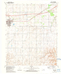
1989 Map of Erick
USGS Topo · Published 1989About this map
Erick stands as the primary hub in this West Oklahoma landscape, revealing a community defined by its civic institutions and energy infrastructure during the late 1980s. The town's layout is anchored by local landmarks including the High School, an Athletic field, and the Post Office, alongside several local churches and a cemetery. Outside the immediate town center, the influence of the region's petroleum industry is clear, with numerous Gas Wells and a significant Pipeline network cutting across the terrain toward the expansive Richland Gas Field.
Find a feature on this map
20 named features on this map. Tap any name to fly to it.
Don’t see what you’re looking for? This feature index may not catch every label — zoom into the map to look around manually.
Map Details
Editions of this 1989 Erick Map
This is the sole edition of this map. No revisions or reprints were ever made.
Other maps of this area

1955 · Clinton
USGS Topo · 1:250,000

1957 · Clinton
USGS Topo · 1:250,000

1960 · Sweetwater
USGS Topo · 1:62,500

1960 · Sayre
USGS Topo · 1:62,500

1961 · Willow
USGS Topo · 1:62,500

1961 · Erick
USGS Topo · 1:62,500

1985 · Elk City
USGS Topo · 1:100,000
1989 · Delhi
USGS Topo · 1:24,000
1989 · Prentiss
USGS Topo · 1:24,000
1989 · Plainview
USGS Topo · 1:24,000