
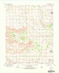
1961 Map of Willow
USGS Topo · Published 1963About this map
Haystack Mountain rises above the plains along the Beckham and Greer county line, serving as a prominent landmark in this western Oklahoma landscape. The area is defined by the winding course of the North Fork Red River, which separates the township of Poarch from Bettina and Willow. This 1961 field-checked survey reveals a rural economy transitioning between traditional agriculture and early energy development, evidenced by several oil wells and numerous gravel pits scattered near Delhi and Carter.
Find a feature on this map
43 named features on this map. Tap any name to fly to it.
Don’t see what you’re looking for? This feature index may not catch every label — zoom into the map to look around manually.
Map Details
Editions of this 1961 Willow Map
2 editions found
Other maps of this area

1955 · Lawton
USGS Topo · 1:250,000

1955 · Clinton
USGS Topo · 1:250,000

1957 · Clinton
USGS Topo · 1:250,000

1960 · Sweetwater
USGS Topo · 1:62,500

1960 · Sayre
USGS Topo · 1:62,500

1961 · Erick
USGS Topo · 1:62,500

1961 · Retrop
USGS Topo · 1:62,500

1961 · Elk City
USGS Topo · 1:62,500

1971 · Mangum North
USGS Topo · 1:24,000

1971 · Vinson
USGS Topo · 1:24,000