2025 Map of Estero
USGS Topo · Published 2025About this map
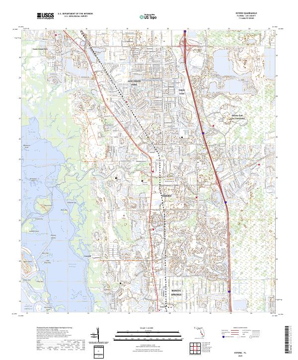
The Estero River flows through a complex geography of Gulf coast mangroves and residential development in this modern survey. The landscape is defined by the extensive Estero Bay Preserve State Park, protecting a shoreline of islands and keys such as Mound Key, Stingaree Key, and Big Hickory Island. Inland, the map documents the growth of Estero and San Carlos Park, alongside the academic grounds of Florida Gulf Coast University. For those researching local heritage, the map identifies significant sites including the Koreshan Unity Cem and Koreshan Cem - 2, which tie back to the area's unique communal history. The transport network is anchored by S Tamiamiami Trl and the Tenmile Canal, illustrating how water management and highway infrastructure have shaped the modern Lee County corridor.
Find a feature on this map
52 named features on this map. Tap any name to fly to it.
Don’t see what you’re looking for? This feature index may not catch every label — zoom into the map to look around manually.
Map Details
Editions of this 2025 Estero Map
This is the sole edition of this map. No revisions or reprints were ever made.
Historical Maps of Timberwalk at Three Oaks Through Time
Featured Locations
- Cranbrook Harbor, FL
- Fountain Lakes, FL
- North Lake Village, FL
- Residences at Coconut Point, FL
- Spring Creek Village, FL