
1947 Map of Exeland
USGS Topo · Published 1947About this map
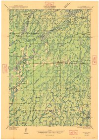
Exeland serves as the primary hub for this timber and river country at the border of Sawyer and Rusk counties. The landscape is deeply defined by its drainage basins, dominated by the Chippewa River and its major tributaries like the Brunet River and Thornapple River. While the terrain is dotted with numerous small lakes such as Windfall Lake and Miller Lake, the human footprint is characterized by a dense network of country school districts. Institutions like Bellisle Falls School, Riverside School, and Dairy Center School reflect a period of decentralized rural education before school consolidation. These schools, alongside landmarks like Brunet Methodist Church and the Exeland Cemetery, provide a precise record of the communities that settled this glacial landscape, showing a pattern of small farmsteads and isolated settlements connected by early state and county highway systems.
Find a feature on this map
61 named features on this map. Tap any name to fly to it.
Don’t see what you’re looking for? This feature index may not catch every label — zoom into the map to look around manually.
Map Details
Editions of this 1947 Exeland Map
This is the sole edition of this map. No revisions or reprints were ever made.
Other maps of this area

1944 · Exeland
USGS Topo · 1:48,000

1944 · Draper
USGS Topo · 1:48,000

1944 · Couderay
USGS Topo · 1:48,000

1944 · Radisson
USGS Topo · 1:48,000

1945 · Meteor
USGS Topo · 1:48,000

1945 · Ingram
USGS Topo · 1:48,000

1947 · Ingram
USGS Topo · 1:48,000
1947 · Draper
USGS Topo · 1:48,000

1947 · Sheldon
USGS Topo · 1:48,000
1948 · Couderay
USGS Topo · 1:48,000