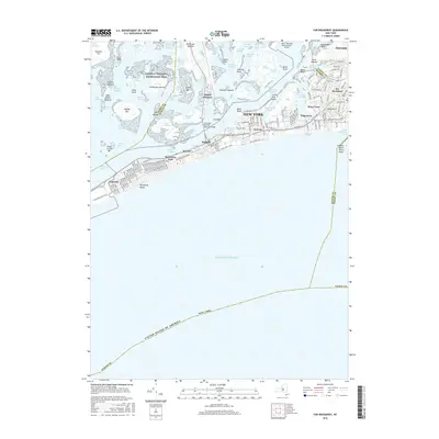
2016 Map of Far Rockaway
USGS Topo · Published 2016About this map
Jamaica Bay and the narrow Rockaway Peninsula define this coastal landscape, where dense urban grids meet a complex network of marshes and tidal channels. On the eastern end, the neighborhoods of Far Rockaway and Wave Crest show a tightly packed residential and commercial pattern served by the Long Island rail line. To the west, the peninsula stretches through Arverne and Rockaway Park toward Neponsit, bounded by the Atlantic Ocean and the protected marshes of the Gateway National Recreation Area. Significant infrastructure is visible, including the southern edge of John F Kennedy International Airport and the Cross Bay Veterans Memorial Bridge connecting the barrier beach to the mainland through Broad Channel. The map details various coastal landforms such as Ruffle Bar and Yellow Bar Hassock, illustrating the sensitive boundary between the city's built environment and its maritime ecosystem.
Find a feature on this map
160 named features on this map. Tap any name to fly to it.
Don’t see what you’re looking for? This feature index may not catch every label — zoom into the map to look around manually.
Map Details
Editions of this 2016 Far Rockaway Map
This is the sole edition of this map. No revisions or reprints were ever made.
Other maps of this area

1889 · Brooklyn
USGS Topo · 1:62,500

1891 · Brooklyn
USGS Topo · 1:62,500

1897 · Brooklyn
USGS Topo · 1:62,500

1897 · Hempstead
USGS Topo · 1:62,500

1898 · Hempstead
USGS Topo · 1:62,500

1898 · Brooklyn
USGS Topo · 1:62,500

1899 · Hempstead
USGS Topo · 1:62,500

1900 · Brooklyn
USGS Topo · 1:62,500

1903 · Hempstead
USGS Topo · 1:62,500
1947 · Brooklyn
USGS Topo · 1:24,000