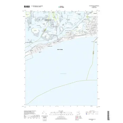
2019 Map of Far Rockaway
USGS Topo · Published 2019About this map
The dense residential street grids of Far Rockaway and Rockaway Park define this barrier island landscape, where the Long Island RR and thoroughfares like Rockaway Beach Blvd connect a string of coastal neighborhoods. The northern reaches are dominated by the intricate wetlands and tidal channels of Jamaica Bay, including the community of Broad Channel and the expansive Gateway National Recreation Area. Significant infrastructure is present throughout, from the Cross Bay Veterans Memorial Bridge spanning the bay to the southern boundary of John F Kennedy International Airport near Motts Basin. Local landmarks like the Global Business Institute and Beis Medrash Heichal Dovid reflect the area's established community character. The map captures the complex geography of Queens where the Atlantic shoreline meets the sheltered waters of Barbadoes Basin and Vernam Basin, illustrating the high-density urban development characteristic of the early 21st century.
Find a feature on this map
124 named features on this map. Tap any name to fly to it.
Don’t see what you’re looking for? This feature index may not catch every label — zoom into the map to look around manually.
Map Details
Editions of this 2019 Far Rockaway Map
This is the sole edition of this map. No revisions or reprints were ever made.
Other maps of this area

1889 · Brooklyn
USGS Topo · 1:62,500

1891 · Brooklyn
USGS Topo · 1:62,500

1897 · Brooklyn
USGS Topo · 1:62,500

1897 · Hempstead
USGS Topo · 1:62,500

1898 · Hempstead
USGS Topo · 1:62,500

1898 · Brooklyn
USGS Topo · 1:62,500

1899 · Hempstead
USGS Topo · 1:62,500

1900 · Brooklyn
USGS Topo · 1:62,500

1903 · Hempstead
USGS Topo · 1:62,500
1947 · Brooklyn
USGS Topo · 1:24,000