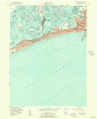
1954 Map of Far Rockaway
USGS Topo · Published 1956About this map
Far Rockaway and the long peninsula of Rockaway Beach are shown here as a dense network of residential streets and coastal infrastructure in the mid-1950s. The landscape is defined by the contrast between the heavily developed shorefront, featuring the long Boardwalk and communities like Neponsit and Belle Harbor, and the complex wetlands of Jamaica Bay to the north. In the bay, islands and marshes such as Ruffle Bar and Canarsie Pol are separated by deep-water arteries like Beach Channel and Black Wall Channel. The map documents a period of significant postwar density, with numerous educational and medical institutions like Jr High Sch No 198 and St Josephs Hospital serving the growing population. Important transit links, including the Cross Bay Bridge and the Long Island railroad line, connect these seaside neighborhoods to the mainland.
Find a feature on this map
88 named features on this map. Tap any name to fly to it.
Don’t see what you’re looking for? This feature index may not catch every label — zoom into the map to look around manually.
Map Details
Editions of this 1954 Far Rockaway Map
This is the sole edition of this map. No revisions or reprints were ever made.
Other maps of this area

1889 · Brooklyn
USGS Topo · 1:62,500

1891 · Brooklyn
USGS Topo · 1:62,500

1897 · Brooklyn
USGS Topo · 1:62,500

1897 · Hempstead
USGS Topo · 1:62,500

1898 · Hempstead
USGS Topo · 1:62,500

1898 · Brooklyn
USGS Topo · 1:62,500

1899 · Hempstead
USGS Topo · 1:62,500

1900 · Brooklyn
USGS Topo · 1:62,500

1903 · Hempstead
USGS Topo · 1:62,500
1947 · Brooklyn
USGS Topo · 1:24,000