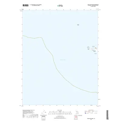
2018 Map of Farallon Islands
USGS Topo · Published 2018About this map
Southeast Farallon and its companion islets rise from the Pacific Ocean in this 2018 survey, providing a detailed look at the landforms of the Farallon Islands. The map focuses on the rocky outcrops of the South Farallon group, where high points like Tower Hill and Main Top dominate the small landmasses. Maritime geography is well-documented, showing the relationship between Maintop Island and the primary island across the narrow channel known as The Jordan. This specific topographical record captures the exact shoreline and named features of this isolated wildlife refuge as they appeared in the early 21st century, including coastal landmarks such as Great West Arch, Arch Rock, and the sheltered waters of Maintop Bay.
Find a feature on this map
11 named features on this map. Tap any name to fly to it.
Don’t see what you’re looking for? This feature index may not catch every label — zoom into the map to look around manually.
Map Details
Editions of this 2018 Farallon Islands Map
This is the sole edition of this map. No revisions or reprints were ever made.
Other maps of this area

1947 · San Francisco
USGS Topo · 1:250,000

1948 · San Francisco
USGS Topo · 1:250,000

1955 · San Francisco
USGS Topo · 1:250,000

1956 · San Francisco
USGS Topo · 1:250,000
1957 · San Francisco
USGS Topo · 1:250,000
1960 · San Francisco
USGS Topo · 1:250,000
1961 · San Francisco
USGS Topo · 1:250,000
1964 · San Francisco
USGS Topo · 1:250,000
1971 · San Francisco
USGS Topo · 1:250,000
1978 · San Francisco
USGS Topo · 1:100,000