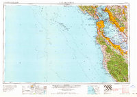
1964 Map of San Francisco
USGS Topo · Published 1964About this map
San Francisco and the surrounding Bay Area appear in the mid-1960s as a dense network of suburban growth and military infrastructure. The peninsula is dominated by established residential centers like Daly City and San Mateo, while the South Bay highlights the academic and industrial footprint of Stanford University and Moffett Field Naval Air Station. Significant land use is dedicated to large necropolises in Colma, including Cypress Lawn Cem and Holy Cross Cem, serving the region's historical genealogical interests.
Find a feature on this map
302 named features on this map. Tap any name to fly to it.
Don’t see what you’re looking for? This feature index may not catch every label — zoom into the map to look around manually.
Map Details
Editions of this 1964 San Francisco Map
This is the sole edition of this map. No revisions or reprints were ever made.
Other maps of this area

1889 · San Jose
USGS Topo · 1:62,500

1892 · San Mateo
USGS Topo · 1:62,500

1895 · San Francisco
USGS Topo · 1:62,500

1896 · San Mateo
USGS Topo · 1:62,500

1896 · Carquinez Strait
USGS Topo · 1:62,500

1896 · Mt. Diablo
USGS Topo · 1:62,500

1897 · San Jose
USGS Topo · 1:62,500

1897 · Concord
USGS Topo · 1:62,500

1897 · Palo Alto
USGS Topo · 1:62,500

1897 · Tamalpais
USGS Topo · 1:62,500