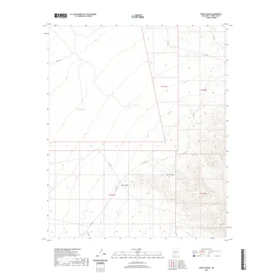
2020 Map of Fence Canyon
USGS Topo · Published 2020About this map
Fence Canyon and the Gyp Hills define the arid landscape of this Sierra County survey, where water management is the primary sign of human activity. The map reveals a network of man-made water catchments, including Bull Pasture Tank, Army Tank, and Fuller Tank, essential for ranching operations in this high-desert environment. These features, along with Middle Tank and East Tank, indicate a land organized around grazing and livestock. Transportation is limited to a grid of county and ranch roads such as E Well Rd, Fuller Rd, and Co Rd A029, which traverse the section lines. The topography transitions from the relatively level terrain of the western sections toward the more complex drainages of Middle Canyon, illustrating the challenging geography that settlers and ranchers negotiated in the late twentieth and early twenty-first centuries.
Find a feature on this map
19 named features on this map. Tap any name to fly to it.
Don’t see what you’re looking for? This feature index may not catch every label — zoom into the map to look around manually.
Map Details
Editions of this 2020 Fence Canyon Map
This is the sole edition of this map. No revisions or reprints were ever made.
Other maps of this area

1916 · Salinas Peak
USGS Topo · 1:125,000

1948 · Sowell
USGS Topo · 1:62,500

1948 · Malpais Well
USGS Topo · 1:62,500

1948 · Black Top Mountain
USGS Topo · 1:62,500

1948 · Salinas Peak
USGS Topo · 1:62,500

1954 · Tularosa
USGS Topo · 1:250,000

1958 · Tularosa
USGS Topo · 1:250,000

1981 · Big Gyp Mountain
USGS Topo · 1:24,000
1981 · Shannon Canyon
USGS Topo · 1:24,000
1981 · Hardscrabble Mountains
USGS Topo · 1:24,000