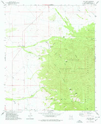
1974 Map of Fife Peak
USGS Topo · Published 1977About this map
The Chiricahua Mountains dominate this 1970s landscape, where the rugged terrain of the Coronado National Forest meets the desert floor. The map highlights a complex network of canyons, including Pine Canyon, Witch Canyon, and Fife Canyon, which serve as natural conduits through the high country. At the center of this drainage system is Fife Peak, standing as a prominent landmark above the surrounding ridges. Settlement is sparse, represented by Oak Ranch and a scattering of water infrastructure essential for cattle and wildlife. Dozens of named water sources such as Bumblebee Tank, Madrono Spring, and Trunk Canyon Tank are documented, alongside numerous unnamed springs. A network of Jeep Trails provides the primary means of access through the steep drainages of Fivemile Creek and Turkey Creek, reflecting the remote and managed nature of the forest during this era.
Find a feature on this map
29 named features on this map. Tap any name to fly to it.
Don’t see what you’re looking for? This feature index may not catch every label — zoom into the map to look around manually.
Map Details
Editions of this 1974 Fife Peak Map
This is the sole edition of this map. No revisions or reprints were ever made.
Other maps of this area

1916 · Pearce
USGS Topo · 1:125,000

1917 · San Simon
USGS Topo · 1:125,000

1917 · Chiricahua
USGS Topo · 1:125,000

1919 · Chiricahua
USGS Topo · 1:125,000

1922 · Willcox
USGS Topo · 1:125,000

1926 · Light
USGS Topo · 1:62,500

1926 · Cochise Head
USGS Topo · 1:62,500

1926 · Rucker
USGS Topo · 1:62,500

1943 · Dos Cabezas
USGS Topo · 1:62,500

1950 · Cochise Head
USGS Topo · 1:62,500