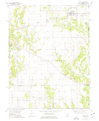
1974 Map of Fillmore
USGS Topo · Published 1977About this map
The Norfolk and Western railroad corridor anchors the northern reach of this mid-1970s landscape, passing through the village of Fillmore and the small station point at Chapman. The terrain is defined by the dendritic patterns of Shoal Creek and its many tributaries, such as Dry Branch and Piatt Creek, which carve through the farmland of South Fillmore and Mulberry Grove. Numerous family and community burial grounds, including Glendale Cem, Walker Cem, and Renshaw Cem, are scattered throughout the quadrangle, serving as vital markers for local genealogical research. In the south, the presence of the Consolidated Field Oil area and several Gravel Pits points to the region's extraction history, while scattered rural houses of worship like East Fork Ch and Hurricane Ch underscore the established social network of these central Illinois townships.
Find a feature on this map
43 named features on this map. Tap any name to fly to it.
Don’t see what you’re looking for? This feature index may not catch every label — zoom into the map to look around manually.
Map Details
Editions of this 1974 Fillmore Map
This is the sole edition of this map. No revisions or reprints were ever made.
Other maps of this area

1932 · Greenville
USGS Topo · 1:62,500

1939 · Greenville
USGS Topo · 1:62,500

1943 · Greenville
USGS Topo · 1:62,500

1944 · Ramsey
USGS Topo · 1:62,500

1945 · Vandalia
USGS Topo · 1:62,500

1946 · Ramsey
USGS Topo · 1:62,500

1947 · Vandalia
USGS Topo · 1:62,500

1947 · Hillsboro
USGS Topo · 1:62,500

1949 · Hillsboro
USGS Topo · 1:62,500

1958 · Decatur
USGS Topo · 1:250,000