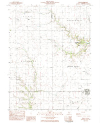
1983 Map of Findlay
USGS Topo · Published 1983About this map
Findlay serves as a central hub for this portion of Shelby County, where the Missouri Pacific railroad line intersects with the rural agricultural landscape. The township boundaries of Penn, Pickaway, and Todds Point converge here, revealing a network of small family and community landmarks. Genealogists will find a wealth of burial sites, including Prairie Home Cem, Foster Cem, and Union Cem, alongside the St Marys Ch. The terrain is defined by the winding paths of Wilborn Creek and Robinson Creek, which cut through the farmsteads. Several private aviation markers, such as the Kroenlein Landing Strip and Enoch Landing Strip, suggest the integration of modern transport into this traditional prairie setting during the early 1980s.
Find a feature on this map
25 named features on this map. Tap any name to fly to it.
Don’t see what you’re looking for? This feature index may not catch every label — zoom into the map to look around manually.
Map Details
Editions of this 1983 Findlay Map
This is the sole edition of this map. No revisions or reprints were ever made.
Other maps of this area

1935 · Sullivan
USGS Topo · 1:48,000

1940 · Sullivan
USGS Topo · 1:62,500

1942 · Shelbyville
USGS Topo · 1:62,500

1946 · Shelbyville
USGS Topo · 1:62,500

1947 · Stewardson
USGS Topo · 1:62,500

1949 · Stewardson
USGS Topo · 1:62,500

1949 · Dalton City
USGS Topo · 1:62,500

1958 · Decatur
USGS Topo · 1:250,000

1961 · Decatur
USGS Topo · 1:250,000

1980 · Middlesworth
USGS Topo · 1:24,000