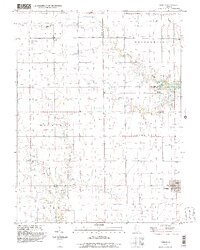
1998 Map of Findlay
USGS Topo · Published 2003About this map
Findlay sits at the heart of this central Illinois landscape, surrounded by the townships of Penn, Marrowbone, and Pickaway. The terrain is defined by the winding paths of Wilborn Creek and Robinson Creek, which carve through the prairie landscape as they flow toward the southeastern edge of the map. This area shows a typical Midwestern grid of rural roads and homesteads, punctuated by scattered local institutions that served the agricultural community at the end of the 20th century. Local landmarks like St Marys Ch and several small rural cemeteries, including Todds Point Cem and Foster Cem, suggest long-established family ties and settlement patterns. Three private aviation sites — Kroenlein Landing Strip, Howell Landing Strip, and Enoch Landing Strip — emphasize the modern agricultural scale of this region.
Find a feature on this map
22 named features on this map. Tap any name to fly to it.
Don’t see what you’re looking for? This feature index may not catch every label — zoom into the map to look around manually.
Map Details
Editions of this 1998 Findlay Map
This is the sole edition of this map. No revisions or reprints were ever made.
Other maps of this area

1935 · Sullivan
USGS Topo · 1:48,000

1940 · Sullivan
USGS Topo · 1:62,500

1942 · Shelbyville
USGS Topo · 1:62,500

1946 · Shelbyville
USGS Topo · 1:62,500

1947 · Stewardson
USGS Topo · 1:62,500

1949 · Stewardson
USGS Topo · 1:62,500

1949 · Dalton City
USGS Topo · 1:62,500

1958 · Decatur
USGS Topo · 1:250,000

1961 · Decatur
USGS Topo · 1:250,000

1980 · Middlesworth
USGS Topo · 1:24,000