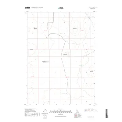
2020 Map of Fingers Butte
USGS Topo · Published 2020About this map
Craters Of The Moon National Preserve dominates the southwestern portion of this high-desert landscape in Butte County. The terrain is defined by a series of volcanic features and isolated rises, including Wildhorse Butte, Cruthers Butte, and Saddle Butte. Human intervention in this arid environment is evidenced by the presence of the Fingers Butte Reservoir, which sits adjacent to the namesake Fingers Butte. This modern survey illustrates the sparse infrastructure of the region, where the unpaved Arco-Minidoka Rd provides a primary point of access through the sagebrush steppe. The map provides a clear look at the township and range divisions across this section of the Snake River Plain, documenting the isolation of landmarks like Huddles Hole within the vast preserve boundaries.
Find a feature on this map
12 named features on this map. Tap any name to fly to it.
Don’t see what you’re looking for? This feature index may not catch every label — zoom into the map to look around manually.
Map Details
Editions of this 2020 Fingers Butte Map
This is the sole edition of this map. No revisions or reprints were ever made.
Other maps of this area

1955 · Idaho Falls
USGS Topo · 1:250,000

1958 · Idaho Falls
USGS Topo · 1:250,000

1972 · Quaking Aspen Butte
USGS Topo · 1:24,000

1972 · Pratt Butte
USGS Topo · 1:24,000

1972 · Arco South
USGS Topo · 1:24,000

1972 · Butte City
USGS Topo · 1:24,000

1972 · Nichols Reservoir
USGS Topo · 1:24,000

1972 · Fingers Butte
USGS Topo · 1:24,000

1972 · Serviceberry Butte
USGS Topo · 1:24,000
1973 · Fissure Butte
USGS Topo · 1:24,000