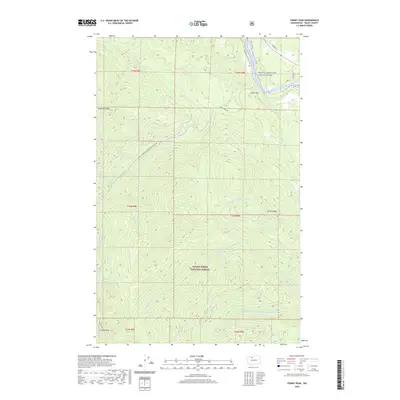
2020 Map of Finney Peak
USGS Topo · Published 2020About this map
Mount Baker National Forest encompasses the vast majority of this 2020 landscape, dominated by the high-elevation drainage systems of the North Cascades foothills. The terrain is defined by prominent landforms such as Finney Peak and Sutter Mtn, with Leonards Ridge and Rinker Ridge forming significant divides between watersheds. The hydrological complexity is evident in the many branches of the Stillaguamish, including the Middle Br N Fork Stillaguamish River, and the Sauk River to the northeast. Human presence is concentrated along the river valleys, notably where the Concrete Sauk Valley Rd parallels the Skagit Wild and Scenic River. This survey captures a region where recreational access, indicated by the Finney Creek Rd 5 Snowmobile Trl (Snow), meets protected riparian corridors and managed timberlands.
Find a feature on this map
30 named features on this map. Tap any name to fly to it.
Don’t see what you’re looking for? This feature index may not catch every label — zoom into the map to look around manually.
Map Details
Editions of this 2020 Finney Peak Map
This is the sole edition of this map. No revisions or reprints were ever made.
Other maps of this area

1899 · Stillaguamish
USGS Topo · 1:125,000

1901 · Stilaguamish
USGS Topo · 1:125,000

1909 · Mt Baker
USGS Topo · 1:192,000

1915 · Mt. Baker
USGS Topo · 1:250,000

1952 · Lake Shannon
USGS Topo · 1:62,500

1952 · Hamilton
USGS Topo · 1:62,500

1955 · Concrete
USGS Topo · 1:250,000

1956 · Oso
USGS Topo · 1:62,500

1958 · Concrete
USGS Topo · 1:250,000

1962 · Concrete
USGS Topo · 1:250,000