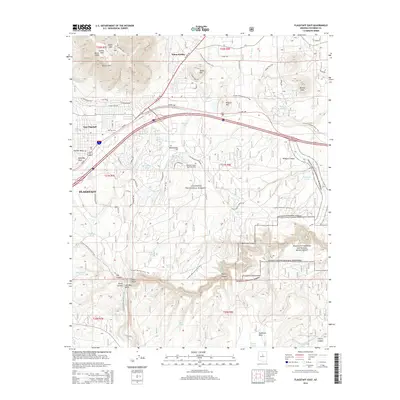
2014 Map of Flagstaff East
USGS Topo · Published 2014About this map
Elden Pueblo and the volcanic landscape of the Turkey Hills dominate this eastern portion of the high desert plateau in the mid-2010s. The map captures the meeting point of deep human history and modern infrastructure, where the Arizona National Scenic Trail winds past ancient geological formations like Bottomless Pit and through the rugged stretches of Coconino National Forest. To the south, the deep incisions of Walnut Canyon National Monument reveal the complex drainage patterns of Walnut Creek, while East Flagstaff expands along the arterial routes of US Hwy 180 and the I-40 Bus. Notable landmarks such as Fisher Point and Anderson Mesa provide clear topographic reference points for a landscape defined by significant elevation changes, from the heights of Elden Mtn down to the recessed basins of Big Fill Lake and Humphrey Lake.
Find a feature on this map
75 named features on this map. Tap any name to fly to it.
Don’t see what you’re looking for? This feature index may not catch every label — zoom into the map to look around manually.
Map Details
Editions of this 2014 Flagstaff East Map
This is the sole edition of this map. No revisions or reprints were ever made.
Other maps of this area

1886 · San Francisco Mtns
USGS Topo · 1:250,000

1891 · San Francisco Mtns
USGS Topo · 1:250,000

1894 · San Francisco Mtns
USGS Topo · 1:250,000

1899 · San Francisco Mtns
USGS Topo · 1:250,000

1908 · Flagstaff
USGS Topo · 1:125,000

1912 · Flagstaff
USGS Topo · 1:125,000

1947 · Flagstaff
USGS Topo · 1:250,000

1954 · Flagstaff
USGS Topo · 1:250,000

1958 · Flagstaff
USGS Topo · 1:250,000

1960 · Flagstaff
USGS Topo · 1:250,000