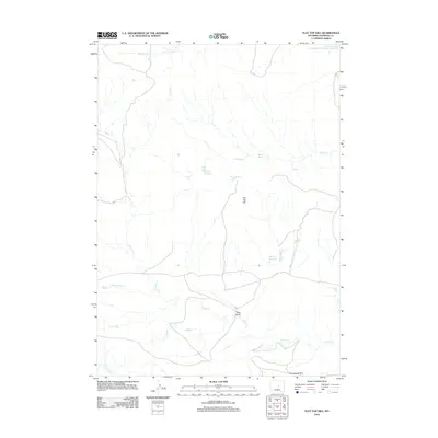
2012 Map of Flat Top Hill
USGS Topo · Published 2012About this map
Flat Top Hill rises above a sparse Natrona County landscape defined by intermittent water sources and high prairie terrain. In this part of the Wyoming interior, life and movement are tied closely to the available water, as seen in the positioning of Big Pike Reservoir and Lower Hackett Creek Reservoir in the northern and central reaches. The drainages of Indian Cr and Alkali Cr cross the quadrangle, carving pathways like Pike Draw through the high ground.
Find a feature on this map
13 named features on this map. Tap any name to fly to it.
Don’t see what you’re looking for? This feature index may not catch every label — zoom into the map to look around manually.
Map Details
Editions of this 2012 Flat Top Hill Map
This is the sole edition of this map. No revisions or reprints were ever made.
Other maps of this area

1955 · Arminto
USGS Topo · 1:250,000

1958 · Arminto
USGS Topo · 1:250,000

1962 · Arminto
USGS Topo · 1:250,000

1968 · First Water Draw
USGS Topo · 1:24,000

1968 · Willow Creek School
USGS Topo · 1:24,000
1968 · Notches Dome
USGS Topo · 1:24,000

1968 · Roughlock Hill
USGS Topo · 1:24,000

1968 · Big Sulfur Draw
USGS Topo · 1:24,000
1968 · Anderson Draw
USGS Topo · 1:24,000

1968 · Flat Top Hill
USGS Topo · 1:24,000