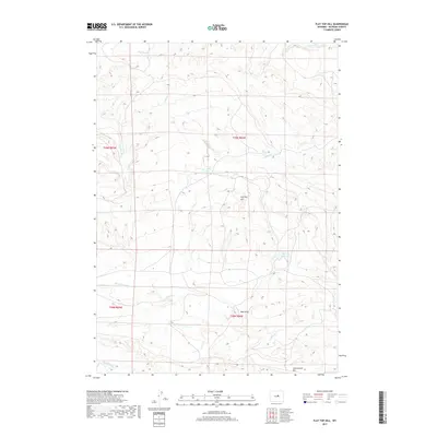
2017 Map of Flat Top Hill
USGS Topo · Published 2017About this map
Flat Top Hill rises as a prominent landmark within this high-desert landscape of Natrona County, defined by a complex network of seasonal watercourses and drainage basins. The area’s water management history is visible through features like Big Pike Reservoir, Willow Reservoir, and Irish Lake, which collect runoff in an otherwise arid environment. Drainages such as Hackett Cr, Alkali Cr, and Indian Cr carve through the terrain, leading toward the distinct elevation of the Cottonwood Rim at the southern edge. The distribution of Bar Spring and small catchment areas like McLaughlin Lake suggests a landscape shaped by the needs of livestock and regional hydrology. This survey provides a clear look at the township and range divisions, showing how land was partitioned across the high plains north of the North Platte River corridor.
Find a feature on this map
17 named features on this map. Tap any name to fly to it.
Don’t see what you’re looking for? This feature index may not catch every label — zoom into the map to look around manually.
Map Details
Editions of this 2017 Flat Top Hill Map
This is the sole edition of this map. No revisions or reprints were ever made.
Other maps of this area

1955 · Arminto
USGS Topo · 1:250,000

1958 · Arminto
USGS Topo · 1:250,000

1962 · Arminto
USGS Topo · 1:250,000

1968 · First Water Draw
USGS Topo · 1:24,000

1968 · Willow Creek School
USGS Topo · 1:24,000
1968 · Notches Dome
USGS Topo · 1:24,000

1968 · Roughlock Hill
USGS Topo · 1:24,000

1968 · Big Sulfur Draw
USGS Topo · 1:24,000
1968 · Anderson Draw
USGS Topo · 1:24,000

1968 · Flat Top Hill
USGS Topo · 1:24,000