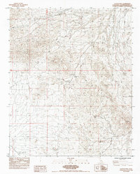
1984 Map of Flattop Mtn
USGS Topo · Published 1984About this map
Flattop Mtn dominates this 1984 topographical survey of San Bernardino County, where the high desert landscape is defined by resource extraction and sparse water management. The area shows evidence of industrial and survival infrastructure, including the Rex Mine and a specialized Guzzler system for capturing runoff. Human presence is concentrated at Browns Camp and around the Hacienda area, while a series of underground pipelines and a dike suggest the critical importance of water transport in this arid environment. The map details a network of 4wd tracks and multiple lanes that cut through the desert terrain, providing access to remote points like the Natural Water Tank and Flattop Mtn Spring. To the southeast, the terrain shifts into the higher elevations of Eagle Peak and the navigable Eagle Pass, illustrating the difficult passage through the eastern San Bernardino range.
Find a feature on this map
20 named features on this map. Tap any name to fly to it.
Don’t see what you’re looking for? This feature index may not catch every label — zoom into the map to look around manually.
Map Details
Editions of this 1984 Flattop Mtn Map
This is the sole edition of this map. No revisions or reprints were ever made.
Other maps of this area

1903 · Needles
USGS Topo · 1:125,000

1904 · Needles Special
USGS Topo · 1:125,000

1943 · Center Hills
USGS Topo · 1:62,500

1943 · Bannock
USGS Topo · 1:62,500

1950 · Sawtooth Range
USGS Topo · 1:62,500

1950 · Needles
USGS Topo · 1:62,500

1951 · Sawtooth Range
USGS Topo · 1:62,500

1952 · Needles
USGS Topo · 1:62,500

1954 · Needles
USGS Topo · 1:250,000

1956 · Needles
USGS Topo · 1:250,000