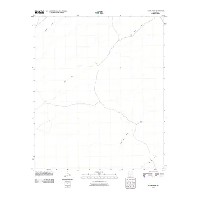
2010 Map of Fleck Draw
USGS Topo · Published 2010About this map
Fleck Ranch and Bruton Camp anchor this arid landscape in Doña Ana County, reflecting the sparse, utilitarian settlement patterns of southern New Mexico. The terrain is defined by a network of drainage systems, most notably Fleck Draw and Gilmore Draw, which demonstrate the natural irrigation and runoff paths essential to ranching operations. The presence of Indian Tank highlights the critical importance of managed water resources in this desert environment, serving as a vital landmark for both local navigation and historical land use. Further south, Horse Camp Draw and New Well Draw reveal the continued reliance on these seasonal watercourses to sustain livestock and seasonal camps in an otherwise demanding environment.
Find a feature on this map
7 named features on this map. Tap any name to fly to it.
Don’t see what you’re looking for? This feature index may not catch every label — zoom into the map to look around manually.
Map Details
Editions of this 2010 Fleck Draw Map
This is the sole edition of this map. No revisions or reprints were ever made.
Other maps of this area

1916 · Tonuco
USGS Topo · 1:125,000

1932 · Tonuco
USGS Topo · 1:125,000

1948 · Chicken Well
USGS Topo · 1:62,500

1948 · Bear Peak
USGS Topo · 1:62,500

1948 · San Diego Mountain
USGS Topo · 1:62,500

1948 · Kaylor Mountain
USGS Topo · 1:62,500

1955 · Las Cruces
USGS Topo · 1:250,000

1958 · Las Cruces
USGS Topo · 1:250,000

1981 · Gilmore Draw
USGS Topo · 1:24,000
1981 · Fleck Draw
USGS Topo · 1:24,000