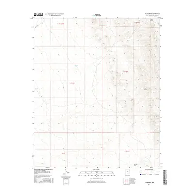
2017 Map of Fleck Draw
USGS Topo · Published 2017About this map
Arid drainages and catchments define this 2017 study of the high desert in Doña Ana County. Named for the ephemeral waterways that carve the landscape, the area features Fleck Draw in the northeast and Gilmore Draw in the northwest, leading toward a terrain marked by scattered water management features like Indian Tank. The southeastern portion of the quadrangle is bisected by Horse Camp Draw, while New Well Draw reaches toward the southern boundary. Human presence is light, primarily represented by the access route Wsmr S Rd 306, which cuts through the northern sections near the junction of several township and range boundaries. This map provides a clear view of the hydrological patterns of the New Mexico desert before modern development or intensive grazing might further alter the surface flow of these seasonal draws.
Find a feature on this map
12 named features on this map. Tap any name to fly to it.
Don’t see what you’re looking for? This feature index may not catch every label — zoom into the map to look around manually.
Map Details
Editions of this 2017 Fleck Draw Map
This is the sole edition of this map. No revisions or reprints were ever made.
Other maps of this area

1916 · Tonuco
USGS Topo · 1:125,000

1932 · Tonuco
USGS Topo · 1:125,000

1948 · Chicken Well
USGS Topo · 1:62,500

1948 · Bear Peak
USGS Topo · 1:62,500

1948 · San Diego Mountain
USGS Topo · 1:62,500

1948 · Kaylor Mountain
USGS Topo · 1:62,500

1955 · Las Cruces
USGS Topo · 1:250,000

1958 · Las Cruces
USGS Topo · 1:250,000

1981 · Gilmore Draw
USGS Topo · 1:24,000
1981 · Fleck Draw
USGS Topo · 1:24,000