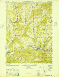
1946 Map of Fleischmanns
USGS Topo · Published 1946About this map
Fleischmanns serves as the focal point of this mid-century topographic survey, situated at the confluence of the Bush Kill and Emory Brook in the heart of the Catskills. The landscape is defined by its deep valleys and high ridges, including Hog Mountain and Fleischmann Mountain, which dictate the paths of the New York Central railroad and the various kills that drain the Delaware River watershed. To the north and west, smaller settlements like Halcottsville, Kelly Corners, and Denver are connected by winding mountain roads through corridors such as Bragg Hollow and Hubbell Hill Hollow. Significant local heritage is preserved in the location of family and community burial grounds, such as Schemehorn Cem and Scudder Cem, as well as several rural schoolhouses. Large portions of the southern terrain are preserved within the Catskill State Park, while industrial and leisure footprints are visible at Lake Switzerland and near Arkville.
Find a feature on this map
53 named features on this map. Tap any name to fly to it.
Don’t see what you’re looking for? This feature index may not catch every label — zoom into the map to look around manually.
Map Details
Editions of this 1946 Fleischmanns Map
This is the sole edition of this map. No revisions or reprints were ever made.
Other maps of this area

1900 · Phoenicia
USGS Topo · 1:62,500

1901 · Margaretville
USGS Topo · 1:62,500

1901 · Gilboa
USGS Topo · 1:62,500

1903 · Gilboa
USGS Topo · 1:62,500

1903 · Phoenicia
USGS Topo · 1:62,500

1904 · Hobart
USGS Topo · 1:62,500

1904 · Margaretville
USGS Topo · 1:62,500
1945 · Seager
USGS Topo · 1:24,000

1945 · West Kill
USGS Topo · 1:24,000

1945 · Fleischmanns
USGS Topo · 1:24,000