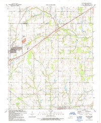
1991 Map of Fletcher
USGS Topo · Published 1991About this map
Fletcher and Sterling anchor this survey of the northern Comanche County landscape, where the Little Washita River winds eastward through the northern reaches of the quadrangle. The area is defined by its deep ties to local heritage, evidenced by the Little Washita Indian Ch and the Washita Indian Cem, alongside the Fletcher Cem. The transportation network is dominated by the H E Bailey Toll Road Turnpike, which cuts diagonally across the terrain, passing a Landing Strip and a significant Quarry near the Fletcher townsite. The southern portion of the map transitions into an active industrial landscape marked by numerous Oil Well and Gas Well sites, particularly around the headwaters of Beaver Creek and Whisky Creek. This documentation reveals the intersection of agricultural roots, energy production, and indigenous history near the Caddo Co Comanche Co line.
Find a feature on this map
21 named features on this map. Tap any name to fly to it.
Don’t see what you’re looking for? This feature index may not catch every label — zoom into the map to look around manually.
Map Details
Editions of this 1991 Fletcher Map
This is the sole edition of this map. No revisions or reprints were ever made.
Other maps of this area

1946 · Lawton
USGS Topo · 1:62,500

1949 · Arbuckle Hill
USGS Topo · 1:24,000

1949 · Cement
USGS Topo · 1:62,500

1949 · Elgin
USGS Topo · 1:24,000

1949 · Nellie
USGS Topo · 1:62,500

1955 · Lawton
USGS Topo · 1:250,000

1956 · Sterling
USGS Topo · 1:24,000

1956 · Laverty
USGS Topo · 1:24,000

1956 · Fletcher
USGS Topo · 1:24,000

1956 · Arbuckle Hill
USGS Topo · 1:24,000