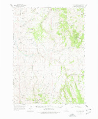
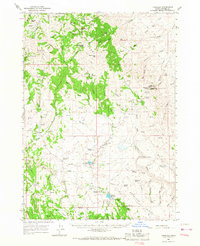
1965 Map of Flint Creek
USGS Topo · Published 1977About this map
Flint stands as a focal point in this high-desert mining landscape of Owyhee County, surveyed in the mid-1960s. The region is defined by a dense concentration of hard-rock mining operations clustered near Dewey Peak and the Silver City Range. Notable claims including the Nellie Ann Mine, Treasure Vault Mine, and Rising Star Mine illustrate the intense geological exploration of the era. This network of mines is supported by a series of primitive transport routes, including a remote Landing Strip and numerous Jeep Trails that traverse the complex drainages of Jordan Creek.
Find a feature on this map
85 named features on this map. Tap any name to fly to it.
Don’t see what you’re looking for? This feature index may not catch every label — zoom into the map to look around manually.
Map Details
Editions of this 1965 Flint Creek Map
This is the sole edition of this map. No revisions or reprints were ever made.
Other maps of this area

1892 · Silver City
USGS Topo · 1:125,000

1894 · Silver City
USGS Topo · 1:125,000

1898 · Silver City
USGS Topo · 1:125,000

1955 · Jordan Valley
USGS Topo · 1:250,000

1955 · Boise
USGS Topo · 1:250,000

1957 · Jordan Valley
USGS Topo · 1:250,000

1958 · Boise
USGS Topo · 1:250,000

1958 · Jordan Valley
USGS Topo · 1:250,000

1962 · Boise
USGS Topo · 1:250,000
1965 · Triangle
USGS Topo · 1:62,500