
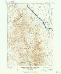
1892 Map of Silver City
USGS Topo · Published 1962About this map
The mining camps of the Owyhee Mountains dominate this late 19th-century landscape, centered on the bustling district of Silver City. Along Jordan Creek, the settlements of De Lamar and Dewey sit near significant industrial operations like the Black Jack Mine, Trade Dollar Mine, and Poorman Mine. These high-altitude ventures required complex supply lines, evidenced by the network of trails leading toward the Snake River to the northeast. Along the river, essential transit points like the Warm Springs Ferry and Bernard Ferry facilitated movement between Owyhee and Canyon Counties. The map reveals a transition from the intense industrial activity at War Eagle Mt and Florida Mt to the agricultural and ranching outposts such as Givens Hot Springs and Murphy in the lower valleys. This survey, led by A.H. Thompson, captures the region at the peak of its silver-mining era.
Find a feature on this map
48 named features on this map. Tap any name to fly to it.
Don’t see what you’re looking for? This feature index may not catch every label — zoom into the map to look around manually.
Map Details
Editions of this 1892 Silver City Map
2 editions found
Other maps of this area

1892 · Boise
USGS Topo · 1:125,000

1892 · Bisuka
USGS Topo · 1:125,000

1894 · Bisuka
USGS Topo · 1:125,000

1894 · Silver City
USGS Topo · 1:125,000

1897 · Boise
USGS Topo · 1:125,000

1898 · Nampa
USGS Topo · 1:125,000

1898 · Silver City
USGS Topo · 1:125,000

1906 · Mitchell Butte
USGS Topo · 1:125,000
1948 · Sinker Butte
USGS Topo · 1:24,000
1949 · Sinker Butte
USGS Topo · 1:24,000