
Loading...
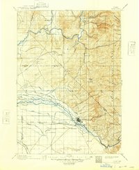
Loading map...1892 Map of Boise
USGS Topo · Published 1892About this map
Boise and the surrounding high desert and mountain terrain are captured here just decades after the city's founding. The settlement landscape is defined by the early development of water infrastructure, including the Phyllis Canal and the Settlers Canal, which signify the transition from mining roots to an irrigation-based agricultural economy. To the north, the winding Payette River passes the small settlement of Marsh and the distinctive Horseshoe Bend.
Find a feature on this map
30 named features on this map. Tap any name to fly to it.
Don’t see what you’re looking for? This feature index may not catch every label — zoom into the map to look around manually.
Map Details
Date Portrayed1892
Date Published1892
PublisherU.S. Geological Survey
Map TypeTopographic
Scale1:125,000
Physical Dimensions16.4 x 19.6 inches
Editions of this 1892 Boise Map
This is the sole edition of this map. No revisions or reprints were ever made.
Historical Maps of Boise Through Time
7 maps found


Featured Locations
Source Details
SourceU.S. Geological Survey
CopyrightPublic Domain