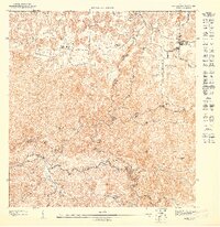
1947 Map of Florida NO
USGS Topo · Published 1947About this map
The agricultural landscape of interior Puerto Rico is depicted here in detail based on 1943 topography, centered around the settlement of Florida. Several historic estates, or haciendas, anchor the local geography, including Hacienda San José in the north and both Hacienda Las Abras and Hacienda Piedra Gorda further south. The terrain is defined by a dense network of steep, conical hills and depressions typical of the region's karst topography, particularly evident near Sumidero and Montaña. Waterways provide the primary orientation for the southern half of the sheet, where the Río Grande de Arecibo meets its tributaries, the Río Yunes and Río Limón. Municipal boundaries for Arecibo, Barceloneta, Ciales, and Utuado converge in this area, illustrating the political intersections of the mountainous highlands during the mid-1940s.
Find a feature on this map
18 named features on this map. Tap any name to fly to it.
Don’t see what you’re looking for? This feature index may not catch every label — zoom into the map to look around manually.
Map Details
Editions of this 1947 Florida NO Map
This is the sole edition of this map. No revisions or reprints were ever made.
Other maps of this area

1942 · Arecibo
USGS Topo · 1:30,000

1942 · Barceloneta
USGS Topo · 1:30,000

1943 · Utuado NE
USGS Topo · 1:10,000

1946 · Barceloneta
USGS Topo · 1:30,000

1946 · Utuado
USGS Topo · 1:30,000

1946 · Arecibo
USGS Topo · 1:30,000

1946 · Florida
USGS Topo · 1:30,000
1947 · Barceloneta SO
USGS Topo · 1:10,000
1947 · Utuado SE
USGS Topo · 1:10,000
1947 · Barceloneta SE
USGS Topo · 1:10,000