
1942 Map of Barceloneta
USGS Topo · Published 1942About this map
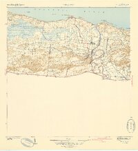
The Central Plazuela and Central Monserrate sugar mills anchor this 1940s landscape, illustrating the industrial backbone of the northern coast during the height of the sugar era. The American Railroad of Puerto Rico and specialized spurs like the Monserrate Central railroad weave through the terrain, connecting the cane fields to the mills and the coastal ports. The Rio Grande de Manati snakes through the eastern section, creating a fertile alluvial plain punctuated by the settlement of Barceloneta. Along the Atlantic shore, points such as Pta Palmas Altas and Pta Boquilla frame a coastline shaped by the massive Caño Tiburones wetlands and smaller estuaries like Caño Matos. The map also captures several smaller community clusters including San Luis, La Aldea, and the coastal village of La Boca, providing a record of local settlement patterns before the mid-century transition to more urbanized layouts.
Find a feature on this map
27 named features on this map. Tap any name to fly to it.
Don’t see what you’re looking for? This feature index may not catch every label — zoom into the map to look around manually.
Map Details
Editions of this 1942 Barceloneta Map
2 editions found
Other maps of this area

1942 · Manati
USGS Topo · 1:30,000

1942 · Arecibo
USGS Topo · 1:30,000

1943 · Utuado NE
USGS Topo · 1:10,000

1946 · Barceloneta
USGS Topo · 1:30,000

1946 · Utuado
USGS Topo · 1:30,000

1946 · Ciales
USGS Topo · 1:30,000

1946 · Arecibo
USGS Topo · 1:30,000

1946 · Florida
USGS Topo · 1:30,000

1946 · Manati
USGS Topo · 1:30,000
1947 · Barceloneta SO
USGS Topo · 1:10,000