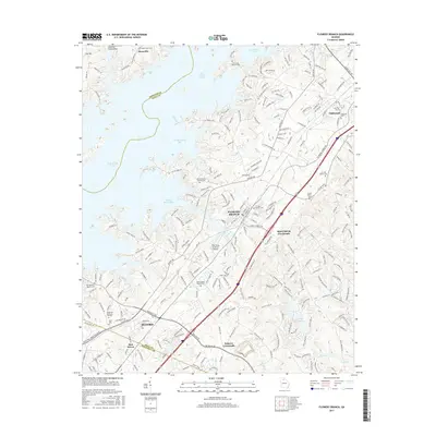
2017 Map of Flowery Branch
USGS Topo · Published 2017About this map
Lake Sidney Lanier dominates the northern and western sections of this map, its intricate shoreline forming dozens of coves such as Chattahoochee Bay and Flowery Branch Bay. This modern survey illustrates the dense residential development and transportation corridors that have grown around the reservoir, particularly within Flowery Branch and the northern reaches of Buford. For genealogists and local historians, several small burial grounds are preserved amid the expanding suburban landscape, including the Young Family Cem and Mount Salem Baptist Cem. The transition from old rural crossroads like Spout Spring Crossroads and Roberts Crossroads to high-capacity thoroughfares is evident through the path of Thurmon Tanner Pkwy and Falcon Pkwy. To the north, the small community of Oakwood serves as a secondary hub, while the The Flying W Ranch Airport reflects the diverse land use of this Hall County region.
Find a feature on this map
65 named features on this map. Tap any name to fly to it.
Don’t see what you’re looking for? This feature index may not catch every label — zoom into the map to look around manually.
Map Details
Editions of this 2017 Flowery Branch Map
This is the sole edition of this map. No revisions or reprints were ever made.
Other maps of this area

1890 · Suwanee
USGS Topo · 1:125,000

1891 · Gainesville
USGS Topo · 1:125,000

1894 · Suwanee
USGS Topo · 1:125,000

1954 · Greenville
USGS Topo · 1:250,000

1955 · Rome
USGS Topo · 1:250,000

1958 · Greenville
USGS Topo · 1:250,000

1958 · Rome
USGS Topo · 1:250,000

1961 · Rome
USGS Topo · 1:250,000

1963 · Rome
USGS Topo · 1:250,000

1964 · Hog Mountain
USGS Topo · 1:24,000