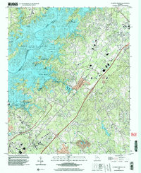
1999 Map of Flowery Branch
USGS Topo · Published 2003About this map
Lake Sidney Lanier dominates the landscape in this late 20th-century survey, its fingers and bays reaching into the rolling hills of Hall, Forsyth, and Gwinnett Counties. The reservoir’s influence is clear through the numerous recreational sites along its banks, including the University Yacht Club, Snug Harbor Marina, and Aqualand Park. Beneath the water's normal pool elevation lie the former sites of historic river crossings, noted now by the Williams Ferry Access Point and Vanns Tavern Access Point.
Find a feature on this map
59 named features on this map. Tap any name to fly to it.
Don’t see what you’re looking for? This feature index may not catch every label — zoom into the map to look around manually.
Map Details
Editions of this 1999 Flowery Branch Map
This is the sole edition of this map. No revisions or reprints were ever made.
Other maps of this area

1890 · Suwanee
USGS Topo · 1:125,000

1891 · Gainesville
USGS Topo · 1:125,000

1894 · Suwanee
USGS Topo · 1:125,000

1954 · Greenville
USGS Topo · 1:250,000

1955 · Rome
USGS Topo · 1:250,000

1958 · Greenville
USGS Topo · 1:250,000

1958 · Rome
USGS Topo · 1:250,000

1961 · Rome
USGS Topo · 1:250,000

1963 · Rome
USGS Topo · 1:250,000

1964 · Hog Mountain
USGS Topo · 1:24,000