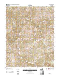
2013 Map of Floyd
USGS Topo · Published 2013About this map
Floyd serves as the central hub of this Blue Ridge upland, where the town street grid transitions into a network of winding mountain roads and farm lanes. The landscape is defined by the headwaters of the Little River and the W Fork Little River, which drain through a series of ridges and knobs. Historic industrial and agricultural sites are noted on the periphery, including Shelors Mill to the southwest and Conner Dairy Farms east of the town center. Local landmarks such as Stockers Knob and the topographic rise of The Haycocks overlook the numerous small valleys formed by Oldfield Cr, Camp Cr, and Terrys Cr. The eastern portion of the map is intersected by the scenic corridor of the Blue Ridge Pkwy, while rural settlements like Poff and Camp Creek illustrate the dispersed residential pattern characteristic of Floyd County.
Find a feature on this map
100 named features on this map. Tap any name to fly to it.
Don’t see what you’re looking for? This feature index may not catch every label — zoom into the map to look around manually.
Map Details
Editions of this 2013 Floyd Map
This is the sole edition of this map. No revisions or reprints were ever made.
Other maps of this area

1890 · Christiansburg
USGS Topo · 1:125,000

1932 · Blacksburg
USGS Topo · 1:48,000

1937 · Blacksburg
USGS Topo · 1:62,500

1950 · Elliston
USGS Topo · 1:62,500

1953 · Winston-Salem
USGS Topo · 1:250,000

1955 · Bluefield
USGS Topo · 1:250,000

1955 · Winston-Salem
USGS Topo · 1:250,000

1957 · Endicott
USGS Topo · 1:62,500

1957 · Floyd
USGS Topo · 1:62,500

1957 · Bluefield
USGS Topo · 1:250,000