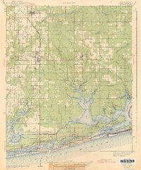
1943 Map of Foley
USGS Topo · Published 1943About this map
Foley and the surrounding Baldwin County landscape are documented here just before the mid-century boom, showing a region defined by its connection to the Gulf and the Louisville and Nashville RR Trail. The map details the intricate coastal geography where Wolf Bay, Arnica Bay, and Bay La Launch meet the Intracoastal Waterway. To the north, the agricultural and timber character of the era is evident in the layout of Summerdale and Elberta, with numerous small schools like Miflin Sch and community landmarks such as Pleasant View Ch serving the rural population. Along the coastline, Gulf State Park and the burgeoning settlements of Gulf Shores and Orange Beach appear alongside the expansive sand dunes, marking the early footprint of Alabama's coastal tourism before the era of intensive development.
Find a feature on this map
76 named features on this map. Tap any name to fly to it.
Don’t see what you’re looking for? This feature index may not catch every label — zoom into the map to look around manually.
Map Details
Editions of this 1943 Foley Map
2 editions found

Other maps of this area

1920 · Robertsdale
USGS Topo · 1:62,500

1921 · Bon Secour
USGS Topo · 1:62,500

1921 · Point Clear
USGS Topo · 1:62,500

1921 · Fairhope
USGS Topo · 1:62,500

1921 · Fort Barrancas
USGS Topo · 1:62,500

1921 · Muscogee
USGS Topo · 1:62,500

1940 · Silverhill
USGS Topo · 1:31,680

1941 · Fort Barrancas
USGS Topo · 1:62,500

1941 · Silverhill
USGS Topo · 1:31,680

1941 · Muscogee
USGS Topo · 1:62,500