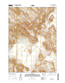
2014 Map of Folly Farm
USGS Topo · Published 2014About this map
Folly Farm sits at the heart of this high-desert landscape on the border of Harney and Malheur counties. The settlement is positioned along Or-78, surrounded by wide alluvial features like Folly Farm Flat and the expansive Sunrise Valley. To the south, the terrain rises into the Sheepshead Mountains, cut by the deep Renwick Canyon. The area’s hydrology is defined by seasonal water features and managed resources, including Porcupine Reservoir and the Duck Creek Lakebed, while smaller water sources like Summit Springs and Black Bull Spring punctuate the arid surroundings. This 2014 survey reveals a territory shaped by ranching and state infrastructure, where the Crowley-Riverside Rd intersects with the local geography at Baker Pass. The map also includes the Turnbull WLS, highlighting the mix of private land use and state-monitored areas characteristic of Southeastern Oregon.
Find a feature on this map
30 named features on this map. Tap any name to fly to it.
Don’t see what you’re looking for? This feature index may not catch every label — zoom into the map to look around manually.
Map Details
Editions of this 2014 Folly Farm Map
This is the sole edition of this map. No revisions or reprints were ever made.
Other maps of this area

1955 · Burns
USGS Topo · 1:250,000

1955 · Adel
USGS Topo · 1:250,000

1957 · Adel
USGS Topo · 1:250,000

1958 · Burns
USGS Topo · 1:250,000

1958 · Adel
USGS Topo · 1:250,000

1959 · Burns
USGS Topo · 1:250,000

1962 · Adel
USGS Topo · 1:250,000

1974 · Anderson Mtn
USGS Topo · 1:62,500
1974 · Turnbull Peak
USGS Topo · 1:24,000
1974 · Folly Farm
USGS Topo · 1:24,000