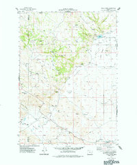
1974 Map of Folly Farm
USGS Topo · Published 1977About this map
Folly Farm and Cord represent vanished footprints of early settlement in this corner of Malheur County, recorded here as they appeared in the mid-1970s. The landscape is defined by its arid basins and volcanic rises, including the Sheepshead Mts and the high point of Duck Creek Butte. Water management is central to the area's history, evidenced by the numerous named springs like Antelope Spring and Black Bull Spring, as well as engineered features like Dowell Reservoir and Brokenlawn Waterhole. The map shows a transition from the elevated terrain of Post Mountain down into the wide Barren Valley and Folly Farm Flat. A remote cemetery and family-named locations such as Dowell Ranch provide important data points for genealogists researching the cattle ranching families who worked these high desert ranges. Historical trails and jeep tracks connect these scattered sites across the sagebrush flats and seasonal lakebeds.
Find a feature on this map
39 named features on this map. Tap any name to fly to it.
Don’t see what you’re looking for? This feature index may not catch every label — zoom into the map to look around manually.
Map Details
Editions of this 1974 Folly Farm Map
This is the sole edition of this map. No revisions or reprints were ever made.
Other maps of this area

1955 · Jordan Valley
USGS Topo · 1:250,000

1955 · Burns
USGS Topo · 1:250,000

1955 · Adel
USGS Topo · 1:250,000

1955 · Boise
USGS Topo · 1:250,000

1957 · Adel
USGS Topo · 1:250,000

1957 · Jordan Valley
USGS Topo · 1:250,000

1958 · Burns
USGS Topo · 1:250,000

1958 · Boise
USGS Topo · 1:250,000

1958 · Adel
USGS Topo · 1:250,000

1958 · Jordan Valley
USGS Topo · 1:250,000