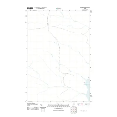
2011 Map of Fool Brook
USGS Topo · Published 2011About this map
Chemquasabamticook Lake dominates the southeastern corner of this North Woods territory, serving as a focal point for seasonal and administrative activity. The presence of Gannett Camp and a Game Warden Camp near the shoreline suggests a landscape managed for both timber and conservation at the start of the 21st century. The interior is defined by an extensive network of industrial logging routes, including Thibodeau Rd, Reality Rd, and Ross Mountain Rd, which provide access to a complex drainage system. Numerous watercourses such as Fool Brook, Sweeney Brook, Mills Brook, and Center Brook carve through the terrain, illustrating the hydrologic patterns that have long dictated movement and land use in this remote section of Somerset County.
Find a feature on this map
13 named features on this map. Tap any name to fly to it.
Don’t see what you’re looking for? This feature index may not catch every label — zoom into the map to look around manually.
Map Details
Editions of this 2011 Fool Brook Map
This is the sole edition of this map. No revisions or reprints were ever made.
Other maps of this area

1954 · Baker Lake
USGS Topo · 1:62,500

1954 · Allagash Lake
USGS Topo · 1:62,500

1954 · Presque Isle
USGS Topo · 1:250,000

1955 · Beaver Pond
USGS Topo · 1:62,500

1955 · Clayton Lake
USGS Topo · 1:62,500

1958 · Presque Isle
USGS Topo · 1:250,000

1960 · Presque Isle
USGS Topo · 1:250,000

1961 · Allagash Lake
USGS Topo · 1:62,500

1962 · Baker Lake
USGS Topo · 1:62,500
1986 · Mary L Pond
USGS Topo · 1:24,000