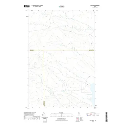
2018 Map of Fool Brook
USGS Topo · Published 2018About this map
The northern Maine woods define this remote section of Somerset, Piscataquis, and Aroostook counties, where the landscape is shaped by the drainages of Fool Brook and Sweeney Brook. This high-altitude drainage basin centers on the convergence of several major timber-access routes including Realty Rd and Boulevard Rd, which navigate the complex topography between various wetlands and streams. The southeastern corner of the map reveals the upper reaches of Chemquasabamticook Lake, a significant water body in the region's hydrographic network. The lack of permanent settlements emphasizes the area's role as a managed timberland, with Ross Mt Rd and Poulin Rd providing the primary human infrastructure amidst the dense network of tributaries like Mills Brook and Center Brook.
Find a feature on this map
13 named features on this map. Tap any name to fly to it.
Don’t see what you’re looking for? This feature index may not catch every label — zoom into the map to look around manually.
Map Details
Editions of this 2018 Fool Brook Map
This is the sole edition of this map. No revisions or reprints were ever made.
Other maps of this area

1954 · Baker Lake
USGS Topo · 1:62,500

1954 · Allagash Lake
USGS Topo · 1:62,500

1954 · Presque Isle
USGS Topo · 1:250,000

1955 · Beaver Pond
USGS Topo · 1:62,500

1955 · Clayton Lake
USGS Topo · 1:62,500

1958 · Presque Isle
USGS Topo · 1:250,000

1960 · Presque Isle
USGS Topo · 1:250,000

1961 · Allagash Lake
USGS Topo · 1:62,500

1962 · Baker Lake
USGS Topo · 1:62,500
1986 · Mary L Pond
USGS Topo · 1:24,000