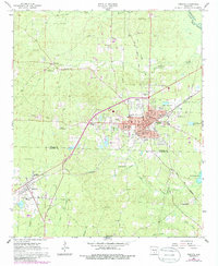
1966 Map of Fordyce
USGS Topo · Published 1986About this map
Fordyce serves as the focal point of this mid-1960s survey, showing a developed rail hub where the ST Louis Southwestern and Fordyce And Princeton lines meet. The town's civic infrastructure is well-documented, from the Courthouse and Hospital to the Fordyce Municipal Airport and Oakland Cemetery. To the west and south, the landscape transitions into a network of small settlements and rural landmarks like Bucksnort and Thornton.
Find a feature on this map
55 named features on this map. Tap any name to fly to it.
Don’t see what you’re looking for? This feature index may not catch every label — zoom into the map to look around manually.
Map Details
Editions of this 1966 Fordyce Map
2 editions found
Other maps of this area

1903 · Camden
USGS Topo · 1:125,000

1953 · El Dorado
USGS Topo · 1:250,000

1957 · El Dorado
USGS Topo · 1:250,000

1958 · El Dorado
USGS Topo · 1:250,000

1960 · El Dorado
USGS Topo · 1:250,000

1966 · Kingsland
USGS Topo · 1:24,000

1966 · Fordyce
USGS Topo · 1:24,000
1969 · Ivan
USGS Topo · 1:24,000
1970 · Fordyce NE
USGS Topo · 1:24,000

1973 · Bearden
USGS Topo · 1:24,000