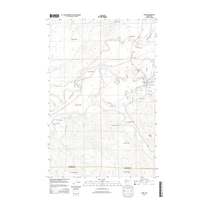
2014 Map of Forks
USGS Topo · Published 2014About this map
Forks serves as the central hub of this Olympic Peninsula landscape, where the confluence of the Sol Duc River, Calawah River, and Bogachiel River dictates the pattern of settlement and transport. In the early 21st century, the area retains its character as a working landscape, evidenced by Campbell Pit and the dense network of timber and access roads like Goodman Mainline Rd. The transition from the residential streets of Forks Prairie to the protected wilderness of Olympic National Park and the Olympic National Forest is immediate, with the Olympic Mountains rising to the southeast. Local history is traced through family-named landmarks like Wilson Ranch and the quiet reaches of Sol Duc Valley. Transportation infrastructure, including the Forks Airport and the Calawah River Bridge, connects this river-rich valley to the wider region.
Find a feature on this map
66 named features on this map. Tap any name to fly to it.
Don’t see what you’re looking for? This feature index may not catch every label — zoom into the map to look around manually.
Map Details
Editions of this 2014 Forks Map
This is the sole edition of this map. No revisions or reprints were ever made.
Other maps of this area

1935 · Ozette Lake
USGS Topo · 1:62,500

1935 · Lake Pleasant
USGS Topo · 1:62,500

1939 · Forks
USGS Topo · 1:62,500

1942 · Ozette Lake
USGS Topo · 1:62,500

1942 · Lake Pleasant
USGS Topo · 1:62,500

1943 · Copalis Beach
USGS Topo · 1:250,000

1951 · Copalis Beach
USGS Topo · 1:250,000

1953 · Cape Flattery
USGS Topo · 1:250,000

1956 · La Push
USGS Topo · 1:62,500

1956 · Ozette Lake
USGS Topo · 1:62,500