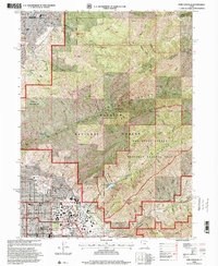
1998 Map of Fort Douglas
USGS Topo · Published 2001About this map
Fort Douglas and the adjacent University of Utah campus anchor this detailed survey of the eastern edge of Salt Lake City, where urban development meets the steep ascent of the Wasatch Mountain range. The map captures a specific moment of transformation as the area prepared for the 2002 Winter Olympics, designating the Olympic Village and Rice-Eccles Stadium. To the east, the landscape transitions into the protected Wasatch National Forest and the Red Butte Canyon Research Natural Area, a preserved watershed nearly untouched by the surrounding city growth. For those tracing local history, the sheet identifies numerous educational and religious landmarks, including Judge Memorial High Sch and St Olaf Sch, alongside the sprawling grounds of the City Cemetery and Mt Olivet Cemetery.
Find a feature on this map
59 named features on this map. Tap any name to fly to it.
Don’t see what you’re looking for? This feature index may not catch every label — zoom into the map to look around manually.
Map Details
Editions of this 1998 Fort Douglas Map
This is the sole edition of this map. No revisions or reprints were ever made.
Other maps of this area

1885 · Salt Lake
USGS Topo · 1:250,000

1925 · Ft. Douglas
USGS Topo · 1:125,000

1928 · Ft. Douglas
USGS Topo · 1:125,000

1950 · Fort Douglas
USGS Topo · 1:24,000

1951 · Fort Douglas
USGS Topo · 1:24,000

1951 · Salt Lake City South
USGS Topo · 1:24,000

1951 · Salt Lake City North
USGS Topo · 1:24,000

1952 · Sugar House
USGS Topo · 1:24,000

1952 · Farmington
USGS Topo · 1:24,000

1952 · Bountiful Peak
USGS Topo · 1:24,000