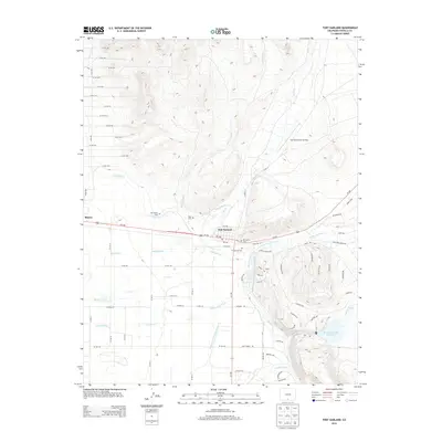
2013 Map of Fort Garland
USGS Topo · Published 2013About this map
Fort Garland and the nearby settlement of Blanca serve as the primary hubs in this high-altitude landscape, where human settlement is defined by an intricate network of water management. The irrigation infrastructure is remarkably dense, featuring the Sangre de Cristo Ditch Number 3, Garland Ditch, and the Sangre de Cristo Trinchera Diversion Canal, all drawing from vital water sources like Ute Cr and Trinchera Cr. For genealogists, the map preserves the locations of several smaller burial sites, including Mac Mullan Cem, Myer Cem, and Brennaman Cem, alongside the larger Ft Garland Cem. The eastern portion of the quadrangle is dominated by the foothills rising toward the Sangre de Cristo Mountains, featuring the Mountain Home Reservoir and the Trinchera Ranch Airstrip, highlighting the area's mix of ranching operations and water storage.
Find a feature on this map
82 named features on this map. Tap any name to fly to it.
Don’t see what you’re looking for? This feature index may not catch every label — zoom into the map to look around manually.
Map Details
Editions of this 2013 Fort Garland Map
This is the sole edition of this map. No revisions or reprints were ever made.
Other maps of this area

1889 · Huerfano Park
USGS Topo · 1:125,000

1892 · Huerfano Park
USGS Topo · 1:125,000

1954 · Trinidad
USGS Topo · 1:250,000

1955 · Trinidad
USGS Topo · 1:250,000

1958 · Trinidad
USGS Topo · 1:250,000

1959 · Trinidad
USGS Topo · 1:250,000

1965 · Blanca
USGS Topo · 1:24,000

1965 · Blanca SE
USGS Topo · 1:24,000

1965 · Twin Peaks
USGS Topo · 1:24,000

1967 · Fort Garland SW
USGS Topo · 1:24,000