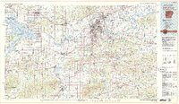
1978 Map of Fort Smith
USGS Topo · Published 1979About this map
Arkansas River navigation and the rugged ridges of the Ouachita foothills define this late 1970s landscape across the Arkansas-Oklahoma border. The urban core of Fort Smith and Van Buren sits at the convergence of the Poteau River and the main river channel, surrounded by industrial infrastructure including massive strip mines to the west and a sprawling Gas Field to the south. Transport corridors like Interstate 40 and several major railroads, including the Kansas City Southern and Missouri Pacific, highlight the region's role as a shipping hub.
Find a feature on this map
73 named features on this map. Tap any name to fly to it.
Don’t see what you’re looking for? This feature index may not catch every label — zoom into the map to look around manually.
Map Details
Editions of this 1978 Fort Smith Map
2 editions found
Other maps of this area

1879 · Poteau Mountain
USGS Topo · 1:62,500

1879 · Cravens
USGS Topo · 1:62,500

1879 · Fort Smith
USGS Topo · 1:62,500

1887 · Poteau Mountain #1
USGS Topo · 1:62,500

1887 · Van Buren
USGS Topo · 1:62,500

1887 · Mount Ida #2
USGS Topo · 1:62,500

1887 · Magazine Mountain #2
USGS Topo · 1:62,500

1887 · Magazine Mountain #3
USGS Topo · 1:62,500

1887 · Watalula
USGS Topo · 1:62,500

1887 · Magazine Mountain
USGS Topo · 1:62,500