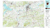
1978 Map of Fort Smith
USGS Topo · Published 1979About this map
Fort Smith sits at the vital confluence of the Arkansas River and Poteau River, serving as a regional anchor during this late 1970s era. The landscape is defined by the heavy infrastructure of the McClellan-Kerr Arkansas River Navigation System, featuring the W D Mayo Lock and Dam and Lock and Dam No 13. Significant land tracts are dedicated to conservation and defense, most notably the Fort Chaffee Military Reservation and the Sequoyah National Wildlife Refuge.
Find a feature on this map
123 named features on this map. Tap any name to fly to it.
Don’t see what you’re looking for? This feature index may not catch every label — zoom into the map to look around manually.
Map Details
Editions of this 1978 Fort Smith Map
2 editions found
Other maps of this area

1879 · Poteau Mountain
USGS Topo · 1:62,500

1879 · Cravens
USGS Topo · 1:62,500

1879 · Fort Smith
USGS Topo · 1:62,500

1887 · Poteau Mountain #1
USGS Topo · 1:62,500

1887 · Van Buren
USGS Topo · 1:62,500

1887 · Mount Ida #2
USGS Topo · 1:62,500

1887 · Magazine Mountain #2
USGS Topo · 1:62,500

1887 · Magazine Mountain #3
USGS Topo · 1:62,500

1887 · Watalula
USGS Topo · 1:62,500

1887 · Magazine Mountain
USGS Topo · 1:62,500