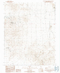
1989 Map of Fourth of July Mountain
USGS Topo · Published 1990About this map
Fourth of July Mountain stands at the center of this 1989 desert landscape, a region deeply marked by mid-century mining operations and water scarcity. The terrain is dotted with numerous extraction sites, including the Big Casino Mines, Chief of the Hills Mines, and New Era Mines, which reveal the intensive prospecting history of southern Nevada. In this arid environment, life and industry centered on rare water sources such as Boat Tank Springs, Summit Spring, and Tip Top Well. The eastern edge of the quadrangle borders the Lake Mead National Recreation Area, while the south opens into the Piute Valley. A lone Grave near the springs serves as a quiet reminder of the isolated life led by miners and ranchers working this remote reach of the Newberry Mountains.
Find a feature on this map
28 named features on this map. Tap any name to fly to it.
Don’t see what you’re looking for? This feature index may not catch every label — zoom into the map to look around manually.
Map Details
Editions of this 1989 Fourth of July Mountain Map
This is the sole edition of this map. No revisions or reprints were ever made.
Other maps of this area

1886 · Camp Mohave
USGS Topo · 1:250,000

1892 · Camp Mohave
USGS Topo · 1:250,000

1926 · Nelson
USGS Topo · 1:96,000

1926 · Mohave City
USGS Topo · 1:96,000

1942 · Camp Mohave
USGS Topo · 1:250,000

1947 · Kingman
USGS Topo · 1:250,000

1948 · Kingman
USGS Topo · 1:250,000

1954 · Kingman
USGS Topo · 1:250,000

1955 · Kingman
USGS Topo · 1:250,000

1958 · Kingman
USGS Topo · 1:250,000