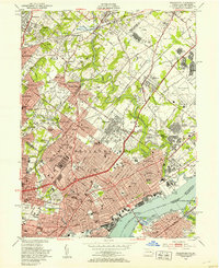
1950 Map of Frankford
USGS Topo · Published 1953About this map
Frankford and the industrial riverfront of Northeast Philadelphia define this mid-century survey, showcasing a densely developed landscape at the height of its manufacturing and institutional significance. The Delaware River forms a vital economic artery, bordered by massive facilities such as the Frankford Arsenal and the House of Correction. Inland, the map reveals the intricate residential and social fabric of neighborhoods like Wissinoming, Tacony, and Mayfair. These communities are bound together by the sprawling Pennypack Park and a complex web of transportation, including the Reading Railroad and the Pennsylvania Railroad. Educational and medical institutions serve as local anchors, from Ogontz College and Cheltenham High Sch to Friends Hospital and Jeanes Hospital. This record captures the transition from established urban centers to burgeoning residential developments like Northeast Village, reflecting the post-war expansion of the city into the surrounding Montgomery County borderlands.
Find a feature on this map
81 named features on this map. Tap any name to fly to it.
Don’t see what you’re looking for? This feature index may not catch every label — zoom into the map to look around manually.
Map Details
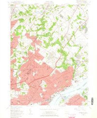
Editions of this 1950 Frankford Map
2 editions found
Other maps of this area

1888 · Mount Holly
USGS Topo · 1:62,500

1890 · Burlington
USGS Topo · 1:62,500

1891 · Philadelphia
USGS Topo · 1:62,500

1893 · Germantown
USGS Topo · 1:62,500

1893 · Burlington
USGS Topo · 1:62,500

1894 · Mount Holly
USGS Topo · 1:62,500

1894 · Philadelphia
USGS Topo · 1:62,500

1894 · Germantown
USGS Topo · 1:62,500

1896 · Germantown
USGS Topo · 1:62,500

1896 · Philadelphia
USGS Topo · 1:62,500
Featured Places
- Philadelphia, PA
- Abington Township, PA
- Cheltenham Township, PA
- Cinnaminson Township, NJ
- Lower Moreland Township, PA