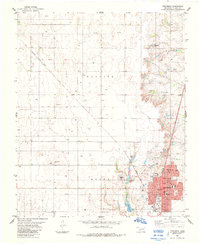
1984 Map of Frederick
USGS Topo · Published 1985About this map
Frederick serves as the focal point of this southwestern Oklahoma survey, showcasing a grid of residential streets like Lillian Ave and Dahlia Ave centered around the courthouse. The town's economic and infrastructure base is clearly defined by its dual rail connections, with the Missouri Kansas Texas and Burlington Northern lines intersecting near the town center. Essential civic landmarks include the High Sch, Central Sch, and County Hosp, alongside industrial features like the Filtration Plant and various Gravel Pits.
Find a feature on this map
34 named features on this map. Tap any name to fly to it.
Don’t see what you’re looking for? This feature index may not catch every label — zoom into the map to look around manually.
Map Details
Editions of this 1984 Frederick Map
This is the sole edition of this map. No revisions or reprints were ever made.
Other maps of this area

1950 · Snyder
USGS Topo · 1:62,500

1955 · Lawton
USGS Topo · 1:250,000

1956 · Manitou
USGS Topo · 1:24,000

1956 · Snyder
USGS Topo · 1:62,500

1958 · Frederick
USGS Topo · 1:62,500

1964 · Tipton SE
USGS Topo · 1:24,000

1964 · Tipton
USGS Topo · 1:24,000

1974 · Hollister NW
USGS Topo · 1:24,000

1974 · Hackberry Flat
USGS Topo · 1:24,000

1975 · Frederick NE
USGS Topo · 1:24,000