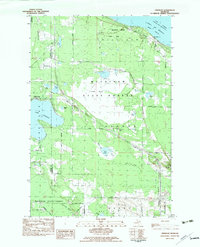
1982 Map of Freedom
USGS Topo · Published 1983About this map
Straits of Mackinac shoreline and the Lake Huron coast define the northern edge of this northern Michigan landscape, where the settlement of Freedom sits near the South Channel. The transition from the coastal waters to the interior is marked by the expansive Dingman Marsh and several significant inland water bodies, including Lake Paradise and Munro Lake. Human activity is centered around the north-south transit corridors, including the Michigan Northern rail line and the Old Railroad Grade. Local civic life and history are anchored at Hebron Town Hall and the nearby Hebron Cem. Much of the territory is preserved within the Mackinaw State Park and Mackinaw State Forest, reflecting a region dominated by protected timberlands and wetlands between Carp Lake and the coastal heights.
Find a feature on this map
41 named features on this map. Tap any name to fly to it.
Don’t see what you’re looking for? This feature index may not catch every label — zoom into the map to look around manually.
Map Details
Editions of this 1982 Freedom Map
This is the sole edition of this map. No revisions or reprints were ever made.
Other maps of this area

1955 · Cheboygan
USGS Topo · 1:250,000

1957 · Mullett Lake
USGS Topo · 1:62,500

1958 · Cheboygan
USGS Topo · 1:250,000

1958 · Pellston
USGS Topo · 1:62,500

1964 · Round Island
USGS Topo · 1:24,000
1964 · St. Ignace
USGS Topo · 1:24,000
1964 · McGulpin Point
USGS Topo · 1:24,000
1982 · Levering
USGS Topo · 1:25,000

1982 · Pellston
USGS Topo · 1:25,000

1982 · Point Nipigon
USGS Topo · 1:25,000
Featured Places
- Hebron Township, MI
- Munro Township, MI
- McKinley Township, MI
- Carp Lake Township, MI
- Mackinaw Township, MI