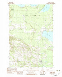
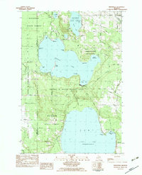
1982 Map of Levering
USGS Topo · Published 1983About this map
Wilderness State Park and the expansive Mackinaw State Forest dominate this northern Michigan landscape, where the shoreline of Cecil Bay meets a network of inland waters. The settlement of Levering serves as a central point for local families, supported by the Church of God and the shared Levering and Carp Lake Cem. The area is characterized by its transition from the structured forestry of the interior to the lakeside developments at Carp Lake and the shores of Lake Paradise. A grid of rural roads, including Michigan Road and Levering Road, connects dispersed locations such as Heils Corner and the Wilderness Golf Course. Numerous smaller bodies of water like French Farm Lake and Galloway Lake dot the terrain, reflecting the region's glacial geography and its reliance on the timber and recreation economies of the late twentieth century.
Find a feature on this map
48 named features on this map. Tap any name to fly to it.
Don’t see what you’re looking for? This feature index may not catch every label — zoom into the map to look around manually.
Map Details
Editions of this 1982 Levering Map
This is the sole edition of this map. No revisions or reprints were ever made.
Other maps of this area

1955 · Cheboygan
USGS Topo · 1:250,000

1957 · Mullett Lake
USGS Topo · 1:62,500

1958 · Cheboygan
USGS Topo · 1:250,000

1958 · Pellston
USGS Topo · 1:62,500

1964 · Big Stone Bay
USGS Topo · 1:24,000
1964 · St. Ignace
USGS Topo · 1:24,000
1964 · McGulpin Point
USGS Topo · 1:24,000

1982 · Pellston
USGS Topo · 1:25,000
1982 · Bliss
USGS Topo · 1:25,000
1982 · Indianville
USGS Topo · 1:25,000