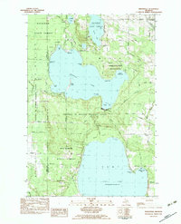
1982 Map of Indianville
USGS Topo · Published 1983About this map
The University of Michigan Biological Station dominates this landscape, spanning the northern and southern shores of Douglas Lake. This scientific research enclave is situated within a dense network of public lands managed as the Mackinaw State Forest, which preserves the transition between the freshwater coastlines and the inland cedar swamps and hardwood ridges. Along the western edge of the map, the Maple River flows south toward the settlement of Indianville, where St Marys Ch serves the local community near the northern tip of Burt Lake. Small clusters of residences and seasonal camps are visible at Ingleside and Lancaster, while the northern survey area includes smaller bodies of water like Munro Lake and Lancaster Lake. These interior waters, linked by systems like the Little Carp River, provided a distinct environment for the university's biological studies and early recreational development in Cheboygan County.
Find a feature on this map
68 named features on this map. Tap any name to fly to it.
Don’t see what you’re looking for? This feature index may not catch every label — zoom into the map to look around manually.
Map Details
Editions of this 1982 Indianville Map
This is the sole edition of this map. No revisions or reprints were ever made.
Other maps of this area

1955 · Cheboygan
USGS Topo · 1:250,000

1957 · Wolverine
USGS Topo · 1:62,500

1957 · Mullett Lake
USGS Topo · 1:62,500

1958 · Cheboygan
USGS Topo · 1:250,000

1958 · Pellston
USGS Topo · 1:62,500

1958 · Petoskey
USGS Topo · 1:62,500

1975 · Petoskey NE
USGS Topo · 1:24,000

1982 · Petoskey
USGS Topo · 1:100,000
1982 · Levering
USGS Topo · 1:25,000

1982 · Pellston
USGS Topo · 1:25,000