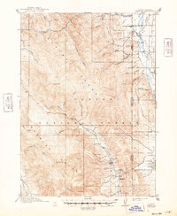
1915 Map of Freedom
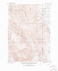
USGS Topo · Published 1948About this map
The Salt River Valley straddles the high border country where the Caribou Range and Webster Range define the horizon. This early twentieth-century landscape is dominated by the historic Lander Cutoff, a vital branch of the Oregon Trail that winds through the mountainous terrain toward the Bear River. The map captures a moment when the regional economy was tied to both cattle ranching and early industry, evidenced by the Petersons Ranch and Miller Ranch alongside the Old Salt Works near Stump Creek. Settlements like Freedom, which features the Freedom School, and Auburn are anchored in the valley flats, while the surrounding high ground is protected as part of the Caribou National Forest. Surveyed before the widespread modernization of mountain roads, the map provides an essential look at the original water sources and drainage patterns of Tincup Creek and its many tributaries.
Find a feature on this map
39 named features on this map. Tap any name to fly to it.
Don’t see what you’re looking for? This feature index may not catch every label — zoom into the map to look around manually.
Map Details
Editions of this 1915 Freedom Map
3 editions found

Historical Maps of Thayne Through Time
1 maps found